by John Jefferson
I heard Ethan Salinsky with Sky Senderos speak recently at the Austin Woods and Waters Club’s September luncheon. Salinsky spoke on their company that offers deer surveys with drones.
My first reaction was that using drones for locating deer for hunting is illegal. I learned that from Federal Game Warden, Jimmy Stinebaugh, whose beat is East Texas and the coastal waterfowl habitat. And that IS the law.
Stinebaugh is a second-generation game warden. His father was both a state and federal game warden and retired as Colonel (director) of the TPWD Law Enforcement Division.
Game surveys are different from my taking a drone to scout our deer lease on opening day. That would get me in trouble. (For the record, I don’t own a drone and presently don’t have a deer lease.)
I asked Ethan if what his company offered was legal. He seemed well versed on the legalities and said they had complied with all regulations.
I looked further before writing this. To conduct a drone survey legally, TPWD White-tailed Deer Program Leader, Blaise Korzekwa, told me individuals or companies must comply with all FAA drone regulations, (as Stinebaugh had told me), have a TPWD Aerial Wildlife
Management Permit, and have the appropriate Landowner Authorization on file with TPWD.
Then I asked Blaise how TPWD felt about drone surveys.
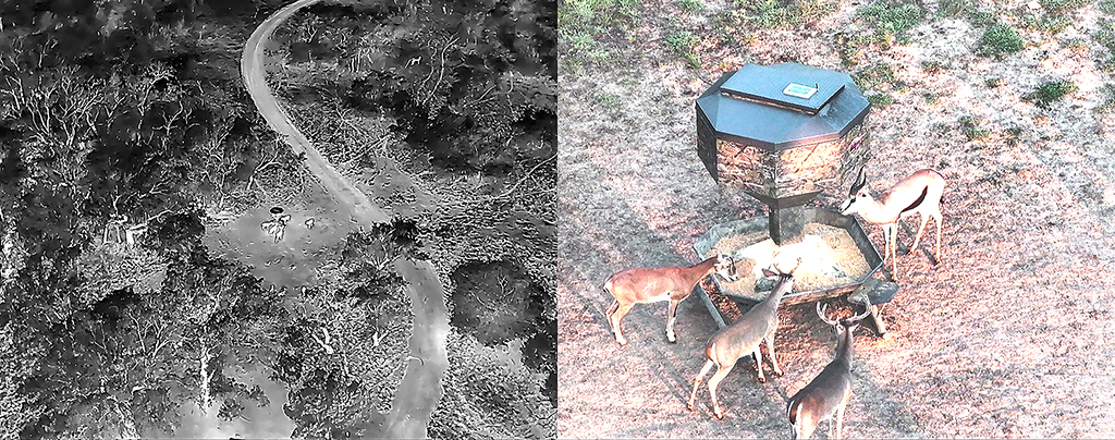
“When using a thermal or FLIR (Forward Looking Infrared), the overall density estimates can be fairly accurate,” Blaise told me, “Oftentimes more accurate than a helicopter survey!”
“Some drone operators,” Blaise added, “also use a drone mounted spotlight in which they can visually ID the species or sex of an animal after detecting it with the thermal camera.”
In the Sky Senderos program that I saw last week, they illustrated this with a split screen look at the thermal image that showed up white in the dark; and next to it on the other screen, the spotlight showed a better look at the animal. One advantage they claim is that the thermal camera could pick out animals in thick brush.
TPWD accepts drone surveys for meeting MLDP requirements if they are done with a thermal or FLIR camera. They have tested that equipment on the Kerr WMA and Caesar Kleberg Wildlife Research Institute has also conducted drone research. Both provided accurate density estimates, but only when using a thermal camera or a FLIR.
I thought their price was high, but Blaise says it compares with helicopter surveys. Landowners or hunters can also see the drone’s work on the Sim card furnished sometime after the flight.
Drones don’t disturb wildlife like helicopters do, and thermal cameras see animals that choppers and countless spotlight counts I’ve done miss. And as much as I like flying in helicopters, they’re riskier. Al Brothers and Larry Weishuhn have both crashed but survived – though Al is still crippled. Several others – including the Texas State Veterinarian –succumbed when their helicopter went down a few years ago.
Drones remove the risk to humans.
Their popularity may well increase.
JJ


