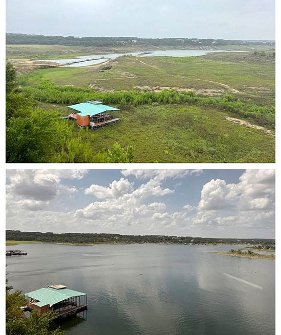
The top half of the picture is Lake Travis on July 3. The bottom half is Travis after the excessive rains over much of the area beginning on July 4. Travis rose to 90% full amazingly fast, as it often does. And Texas is only about halfway through hurricane season. As LCRA has said, with practically full reservoirs, anything could happen. Be vigilant! (Photo by John Jefferson)
by John Jefferson
Our Water Worries Are Over!
Lake Buchanan is now considered FULL! Lake Travis is just short of full! Both benefitted from early July rainfall. Fortunately, rain fell over much of the upper Colorado River Watershed. So, what is there to worry about?
According to John Hoffman, Lower Colorado River Authority (LCRA) Executive Vice President of Water, anything could occur.
He pointed out for those who didn’t already know, that many live near the Colorado River as it passes through San Saba, Llano, Burnet, and Travis counties in what’s called “Flash Flood Alley.”
Mr. Hoffman described our rainfall condition as: “It’s droughts and floods, and floods and droughts, and then more droughts, and then, you guessed it, another flood. “
His summation supports my answer whenever I’m asked if Travis will ever refill during infamous droughts – “Of course it will!”
Due to the limestone base and the hills and draws throughout this picturesque and beloved landscape, a severe cloudburst can send massive walls of water down its formerly dry creek beds before warnings can be posted, as the Guadlupe River did on July 4.
A friend told me of seeing such a torrent come down Shoal Creek in Central Austin once. It picked up a small campfire, carrying it downstream intact — still burning!
Another time, a female law enforcement officer drove hurriedly to check a Bull Creek crossing and was swept away tragically by the sudden surge of raging water as she got out to see if the creek was rising. It happens quickly.
Lakes Buchanan and Travis are water supply reservoirs. They are designed to fluctuate. When I first moved to Austn, a friend referred to Travis as one of the two “Orphan Lakes,“ meaning their water is taken as needed while the constant level lakes are protected during droughts. Those other lakes in the Highland Lakes chain – Inks, LBJ, Marble Falls, and Austin — are kept at non-fluctuating levels. Lady Bird Lake is also included, although operated by the City of Austin, and usually held at constant level.
But if significant rain falls upstream on the Colorado River above the full Lake Buchanan, the rise in the lake will probably pass through on its way to Lake Travis.
Rains in the Junction area also flow down the Llano River and empty into Lake LBJ, which passes them on toward Travis.
And a third arm to Mr. Hoffman’s unknown things that could occur is the Pedernales River watershed. It carries rainwater from the Fredericksburg hills on into Travis.
Farther southwest, the Guadalupe River moves rainwater from the western Hill Country into Canyon Lake and beyond.
People living on or near any river course in “Flash Flood Alley” must pay attention to upstream storms as never before due to already full reservoirs. It would help if area newspapers like the Austin American Statesman reported that instead of national weather coverage elsewhere many miles away.
More floods could come quickly. Having a plan could save lives. Like good Boy Scouts, we should be prepared.
JJ