Texas Crop & Weather Report
by Adam Russell
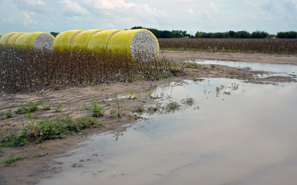
Texas weather conditions emerged from one of the hottest, driest summers on record into the wettest two-month period on record, according to the Texas state climatologist.
Dr. John Nielsen-Gammon reported statewide temperatures from May through August were tied for the second hottest on record, and summer 2018 was also drier, with statewide precipitation levels through August running 3 inches below average, ranking the year to date as the 27th driest on record.
But conditions changed drastically beginning in September, which he said was the fourth wettest month statewide on record with 6.77 inches of rainfall on average. October was even wetter with over 7 inches of rain on average, which made it the second wettest month on record.
“Already at the end of October Texas has received more rainfall than it receives on average in an entire year,” Nielsen-Gammon said.
The high rainfall amounts in September and October made it easily the wettest two-month period on record, he said.
“It’s fairly common to follow droughts with heavy rainfall,” he said. “That happened in 1957 and 2015 where you had extended drought followed by rain and flooding.”
Of the 10 climatic regions around the state, Nielsen-Gammon said four had stations that recorded more than 30 inches of rain over the past 60 days. Some notable observations include, 45.03 inches near Galveston – the highest reported total; 32.65 inches in Madisonville; 33.65 in Bonham; 31.65 inches near Rock Springs; 24.24 in Haskell; 22.38 in San Antonio; 18.27 in Harlingen; and 15.3 inches in Tahoka.
One important exception was Amarillo, which received 4.64 inches and remained one of the drought areas in the state along with parts of the Trans Pecos region, Nielsen-Gammon said.
“The last 60 days has pretty much wiped out all of the color from the drought monitor map for most of the state,” he said.
Nielsen-Gammon said the state didn’t catch any rain from Atlantic tropical storms but caught significant rains from Pacific tropical storms that made their way through Mexico and into Texas. This year was the most active East Pacific hurricane season ever, which typically allows for significant rainfall from thunderstorms in Texas.
Texas also experienced a few cold fronts that stalled out across the state bringing repeated rain activity day after day, he said.
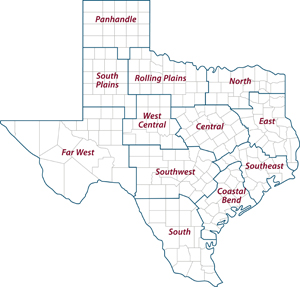
AgriLife Extension district reporters compiled the following summaries:
CENTRAL: The district received more rain. Cotton, hay and pecan producers needed to harvest, but the ground was saturated and will take several days of dry weather before they can access fields. Planting winter crops, including wheat, was also proving to be very difficult. It was estimated that 50 percent of grains were planted. Cotton was a disaster. Livestock were doing OK on pasture. All counties reported good soil moisture. Half the counties reported good overall pasture and rangeland conditions. Most crop conditions were poor.
ROLLING PLAINS: Fall weather set in with cooler temperatures and plenty of moisture. Fields, pastures and rangelands were saturated. Winter wheat was in good to excellent condition, except for the acres under water. Cotton fields were in good condition, but the recent moisture caused open bolls to string out. Farmers were hoping for some dry, warmer weather in hopes to get into fields within the next few weeks to defoliate cotton acres or begin harvesting. Livestock were in good condition with plenty of grazing. Pastures looked better than they have all year.
COASTAL BEND: No report.
EAST: Rainfall slowed and even stopped in some counties. Cherokee County ponds and creeks were full. The Trinity River receded, and the flood warnings were canceled. Anderson County reported pastures were too wet to plant, forcing small grain and ryegrass planting to be put on hold. Panola, Trinity and Sabine counties were able to cut and roll hay in many pastures, but muddy bottomlands claimed tractors and cutters. Pasture and rangeland conditions were excellent in Sabine County, while Trinity County reported very poor conditions. All other counties reported good to fair pasture and rangeland conditions. Anderson and Gregg counties’ hay supplies were at critically low levels with extremely expensive prices. Many producers cut standing hay supplies into silage. Gregg County soil conditions returned to normal and temperatures were warmer inducing good growth in warm-season forages. Henderson, Wood and Upshur counties started winter forage planting. Subsoil conditions were at a surplus in Angelina, Cherokee, Henderson, Polk and Shelby counties. All other counties reported adequate subsoil conditions. Topsoil conditions in Angelina, Cherokee, Polk, Shelby and Trinity were at a surplus, and all other counties reported adequate topsoil conditions. Jasper County reported fall gardens were doing well for producers due to high moisture. Cattle prices per hundredweight in Shelby County were steady, while prices per hundredweight in Gregg County were on the rise across the board. Livestock were in good condition throughout the district. Wild pigs were wreaking havoc throughout Anderson, Henderson, Shelby, Trinity, Wood and Upshur counties. Armyworms were still an issue in Henderson County pastures and on small grain plantings in Anderson County.
SOUTH PLAINS: Subsoil and topsoil moisture levels continued to be saturated with additional rains. Harvest was halted until drier conditions return. Warmer and drier conditions should allow fields to dry out for harvest. Some farmers sprayed or resprayed cotton defoliant. If dry and warmer conditions continue, producers could get remaining crops harvested and plant winter wheat and oats. However, pasture, rangeland and winter wheat will benefit from the recent moisture. Cattle continued to be in good condition.
PANHANDLE: Temperatures were near-normal with a few days above normal near the end of the reporting period. Soil moisture was mostly adequate. Rains delayed cotton harvest for most producers. Wheat fields were booming. Cattle producers were beginning to prepare to turn out yearlings on wheat pasture. Deaf Smith County producers were trying to get into fields following heavy rains the previous reporting period. Silage chopping began in limited areas. Cotton bolls were opening, and producers were waiting for drier conditions to harvest. In Hall County, a few warm, dry days allowed producers to harvest cotton and peanuts in a few fields. Pasture and cattle conditions looked good.
NORTH: Temperatures were cooler with highs in the mid-70s. Rains continued throughout the reporting period with totals ranging from half an inch to 3 inches. Topsoil moisture was extremely high with most counties reporting surplus conditions. Fields remained waterlogged, which has delayed soybean, cotton and hay harvests and winter wheat plantings. Planted winter pastures were yellow and not growing much at all. Cooler night temperatures started shutting summer grass growth down. Cattle looked OK for the most part, and there were a lot of calves weaned and shipped straight to market this month. Most producers were not working calves due to muddy cattle pens.
FAR WEST: Nighttime temperatures dropped into the 30s due to a cold front that gave way to highs in the 80s later in the reporting period. Rain amounts averaged between 0.5-3 inches. The ground was overly saturated making it hard to work in fields. Producers estimated seven to 10 days of dry weather would be needed to access fields and begin the cotton harvest. Cotton fields were taking a hit as open bolls and rain caused stringy fiber. Any wet weather will put the remaining cotton crop on the ground. Losses were already very high due to previous drought conditions that caused most dryland farmers to report their cotton crop as failed. Winter wheat and haygrazer were planted, and rains helped establishment and growth. Pecan trees were looking good with adequate moisture. Pastures were improving with increased heat units, but producers continued to feed livestock and wildlife.
WEST CENTRAL: Conditions were somewhat drier with additional rains. Rainfall totals for the most recent 60-day period ranged from 20-25 inches throughout the district. Rains were causing delays in cotton maturity and harvest. Grades and yields were expected to suffer. Rains also halted wheat planting, but emerged wheat fields were in very good condition. Some final hay harvesting was also delayed. Producers were unsure if they would get their hay harvested before a freeze. Rangelands and pastures were in good to excellent condition. Sales at local cattle markets decreased due to extremely wet conditions. Stocker and feeder steers and heifers sold steady. Packer bulls sold $2 lower per hundredweight, and cows sold $4 lower. Very few bred cows and pairs were marketed.
SOUTHEAST: Slow, steady rain throughout the past few reporting periods saturated the soils in many areas. But dry weather this reporting period helped dry the ground a little. Continuous rains delayed cotton and bean harvests, which likely will result in quality losses. Some pastures were still under water in river bottoms. Many creeks flooded and limited access to lower fields. Some producers wanted to make a final cutting of hay due to short supplies, but conditions were not dry enough. There were no reports of mosquitoes and armyworms. Livestock were in good condition. Rangeland and pasture ratings were excellent to poor with good ratings being most common. Soil moisture levels ranged were adequate to surplus with adequate being most common.
SOUTHWEST: Recent rains delayed cotton harvest and reduced fiber quality and yields. Producers reported about 15 percent of the lint ended up on the ground. Some cotton started growing again, and there was a small amount of seed sprouting reported. Many hay fields needed to be cut and baled, but those fields needed to dry extensively before producers can access them with equipment. Soil moisture levels mostly exceeded saturation. Forage was abundant. Livestock recovered from late-summer shortages and were in good condition.
SOUTH: Northern parts of the district reported mild weather and adequate soil moisture levels. Eastern parts of the district reported mild weather with adequate to surplus soil moisture levels. Cooler weather conditions were reported in the southernmost parts of the district with adequate soil moisture levels. Western parts of the district reported wet weather conditions with adequate to surplus soil moisture levels. Live Oak County reported 15 to 30-plus inches of rain over the last 50 days and reported soggy conditions. Scattered showers delayed most field work. Peanut digging started in some counties and continued in others. Wheat and oat planting were delayed in some areas. Moisture was good for forage production over the last 30 days. Rangeland and pasture conditions were good to excellent. Ranchers and deer breeders had plenty of vegetation for their cattle and wildlife. Some fall armyworm activity continued in a few areas. Body conditions scores on cattle remained good with weaning and shipping of fall calves continuing. Irrigated fields were in good condition. Watermelons and cantaloupes were harvested, and Coastal Bermuda grass fields were going dormant. Zavala County reported semi-dry weather patterns allowed for some farm field activities to resume such as spinach, cabbage and wheat planting. Pecan harvest was near completion. Cotton ginning was very active. Stock tanks were full. Horn flies were becoming a problem on cattle, and some producers began treatments. In Hidalgo County, sugarcane and citrus harvests and vegetable planting were delayed or slowed due to wet fields.


